Geographic Data Science - Lecture VII
Grouping Data over Space
Dani Arribas-Bel
Today
- The need to group data
- Geodemographic analysis
- Non-spatial clustering
- Regionalization
- Examples “in the wild”
The need to group data
Albert Einstein
The need to group data
- The world is complex and multidimensional
- Univariate analysis focuses on only one dimension
- Sometimes, world issues are best understood as multivariate. E.g.
- Percentage of foreign-born Vs. What is a neighborhood?
- Years of schooling Vs. Human development
- Monthly income Vs. Deprivation
Grouping as simplifying
- Define a given number of categories based on many characteristics (multi-dimensional)
- Find the category where each observation fits best
- Reduce complexity, keep all the relevant information
- Produce easier-to-understand outputs
Geodemographic analysis
Geodemographic analysis
|

|
How do you segment/cluster observations over space?
- Statistical clustering
- Explicitly spatial clustering (regionalization)
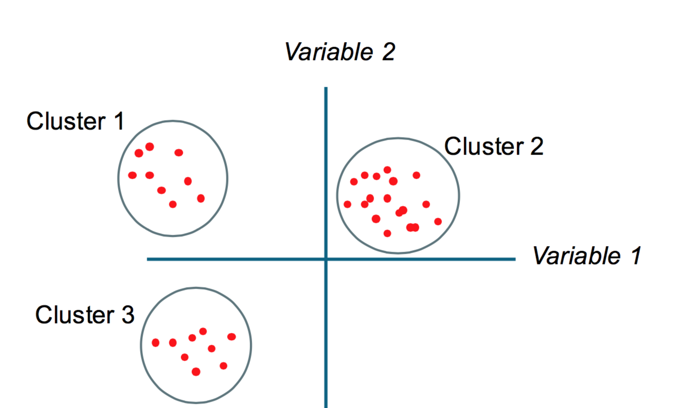
Non-spatial clustering
Split a dataset into groups of observations that are similar within the group and dissimilar between groups, based on a series of attributes
Machine learning
The computer learns some of the properties of the dataset without the human specifying them
Unsupervised
There is no a-priori structure imposed on the classification → before the analysis, no observations is in a category
Intuition
K-means [Source]
More clustering…
- Hierarchical clustering
- Agglomerative clustering
- Spectral clustering
- Neural networks (e.g. Self-Organizing Maps)
- DBSCAN
- …
Different properties, different best usecases
See interesting comparison table
Regionalization
Unsupervised Spatial Machine Learning
Aggregating basic spatial units (areas) into larger units (regions)
Regionalization
Split a dataset into groups of observations that are similar within the group and dissimilar between groups, based on a series of attributes…
…with the additional constraint observations need to be spatial neighbors
Regionalization
- All the methods aggregate geographical areas into a predefined number of regions, while optimizing a particular aggregation criterion;
- The areas within a region must be geographically connected (the spatial contiguity constraint);
- The number of regions must be smaller than or equal to the number of areas;
- Each area must be assigned to one and only one region;
- Each region must contain at least one area.
Algorithms
- Automated Zoning Procedure (AZP)
- Arisel
- Max-P
- …
See Duque et al. (2007) for an excellent, though advanced, overview
Examples
Non-spatial clustering
Regionalisation
Census geographies
Recapitulation
- Some problems are truly highly dimensional and univariate representations are not appropriate
- Clustering can help reduce complexity by creating categories that retain statistical information but are easier to understand
- Two main types of clustering in this context:
- Geo-demographic analysis
- Regionalization
<a rel="license" href="http://creativecommons.org/licenses/by-sa/4.0/"><img alt="Creative Commons License" style="border-width:0" src="https://i.creativecommons.org/l/by-sa/4.0/88x31.png" /></a><br /><span xmlns:dct="http://purl.org/dc/terms/" property="dct:title">Geographic Data Science'19</span> by <a xmlns:cc="http://creativecommons.org/ns#" href="http://darribas.org" property="cc:attributionName" rel="cc:attributionURL">Dani Arribas-Bel</a> is licensed under a <a rel="license" href="http://creativecommons.org/licenses/by-sa/4.0/">Creative Commons Attribution-ShareAlike 4.0 International License</a>.